Atlantic Hurricane Season (2025)
Atlantic Hurricane Season - 2024 Recap and 2025 Forecast
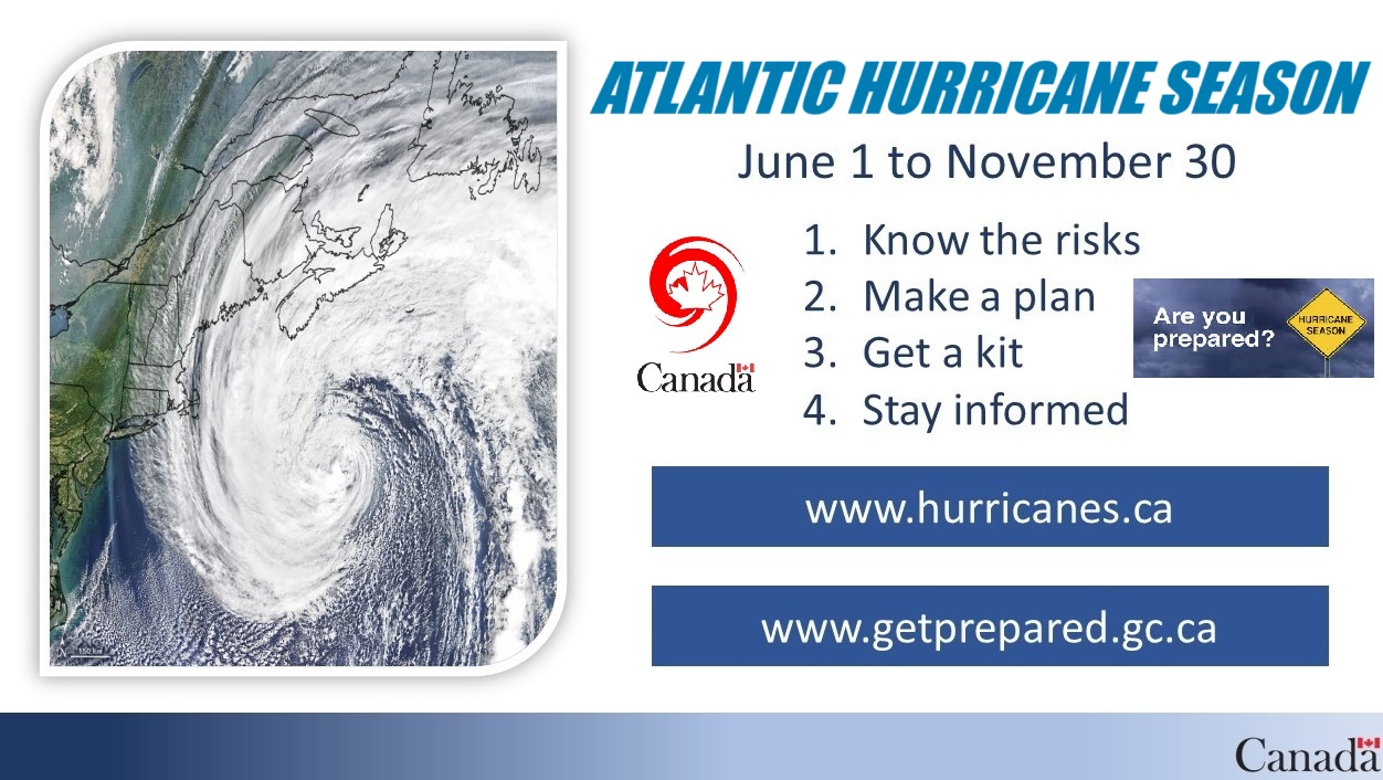
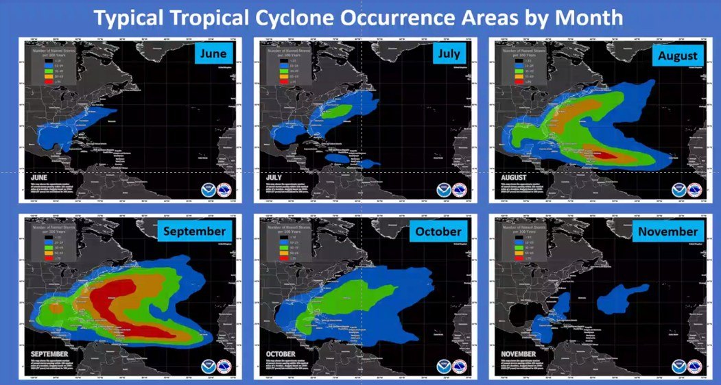
Atlantic hurricane season runs from June 1st to November 30th, although the risk of hurricanes in Nova Scotia is highest during the months of September and October. Hurricanes are classified by categories ranging from 1 to 5. Regardless of the category a hurricane can cause extensive damage. Wind is responsible for much of the structural damage, as well as the uprooted trees and the downed power lines. Even a significantly weakened hurricane can carry winds strong enough to cause widespread destruction.
In Nova Scotia, no hurricanes made direct landfall, but the province still felt the impact. Several systems brought heavy rain, strong winds, and localized flooding. These conditions led to power outages and prompted preparedness alerts from provincial emergency officials.

2025 Forecast
The 2025 Atlantic hurricane season is expected to be more active than usual. Forecasts predict 13 to 19 named storms, with 6 to 10 of those developing into hurricanes and 3 to 5 becoming major hurricanes, defined by sustained winds over 119 km/h. Warmer sea surface temperatures and other favorable weather conditions are contributing to this outlook. Residents of Nova Scotia are encouraged to take steps now to prepare—review emergency plans, check emergency kits, and stay alert to local weather updates as the season approaches.

2025 Tropical Storm Updates (Current or Past Storms)
CANADIAN HURRICANE TRACKER
To check on the status of current Hurricane's please check the Hurricane Tracker:
https://weather.gc.ca/hurricane/track_e.html
CURRENT TROPICAL SYSTEM:
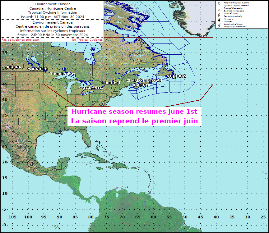
As of 2025-06-26
NAMED STORMS - 3
HURRICANES - 0
MAJOR HURRICANES - 0
Monthly Breakdowns
JUNE (2)
🌀ANDREA (TS)


🌀BARRY (TS)


JULY (1)
🌀CHANTAL (TS)


AUGUST (-)
🌀
SEPTEMBER (-)
🌀
OCTOBER (-)
🌀
NOVEMBER (-)
🌀
About Hurricanes
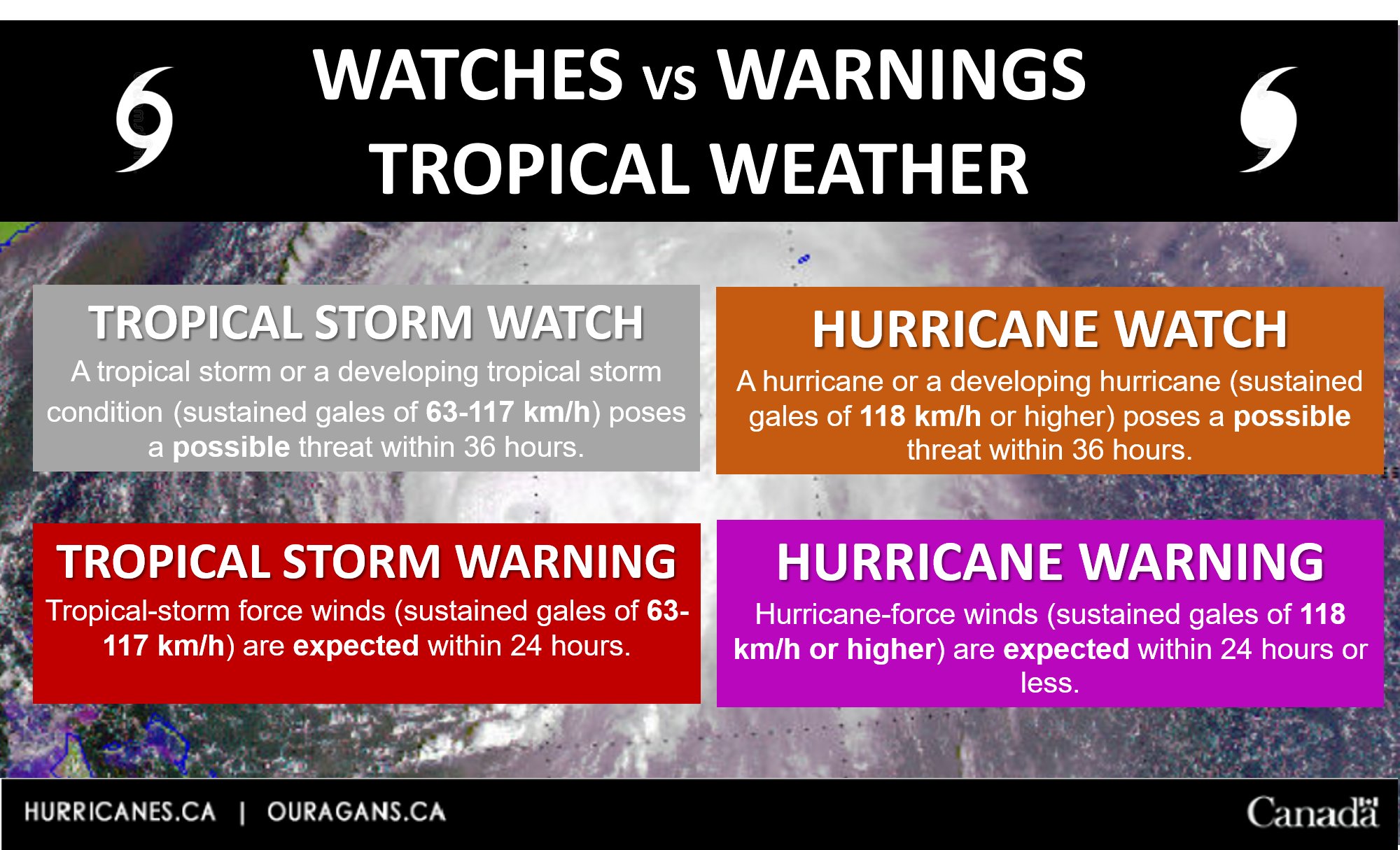
Here are the key differences between a “Tropical Storm Watch” or a “Tropical Storm Warning” and “Hurricane Watch” or a “Hurricane Warning”, as issued by Environment Canada:
Tropical Storm Watch:
- Meaning: Issued when there is a potential for tropical storm conditions (sustained winds of 63-118 km/h) to develop in the area, usually within the next 36 to 48 hours.
- Purpose: Alerts people to the possibility of tropical storm conditions and the need to start preparations.
Tropical Storm Warning:
- Meaning: Issued when tropical storm conditions (sustained winds of 63-118 km/h) are expected to affect the area within the next 24 to 36 hours.
- Purpose: Urges people to take immediate action to protect themselves and their property as tropical storm conditions are imminent.
Hurricane Watch:
- Meaning: Issued when there is a potential for hurricane conditions (sustained winds of 119 km/h or higher) to develop in the area, typically within the next 36 to 48 hours.
- Purpose: Alerts people to the possibility of hurricane conditions so they can prepare.
Hurricane Warning:
- Meaning: Issued when hurricane conditions (sustained winds of 119 km/h or higher) are expected to affect the area within the next 24 to 36 hours.
- Purpose: Signals that immediate action is necessary to protect life and property, as hurricane conditions are imminent.
In summary, "watches" indicate that conditions are possible and people should be prepared, while "warnings" mean that conditions are expected and people should take immediate protective actions.
Did you know?
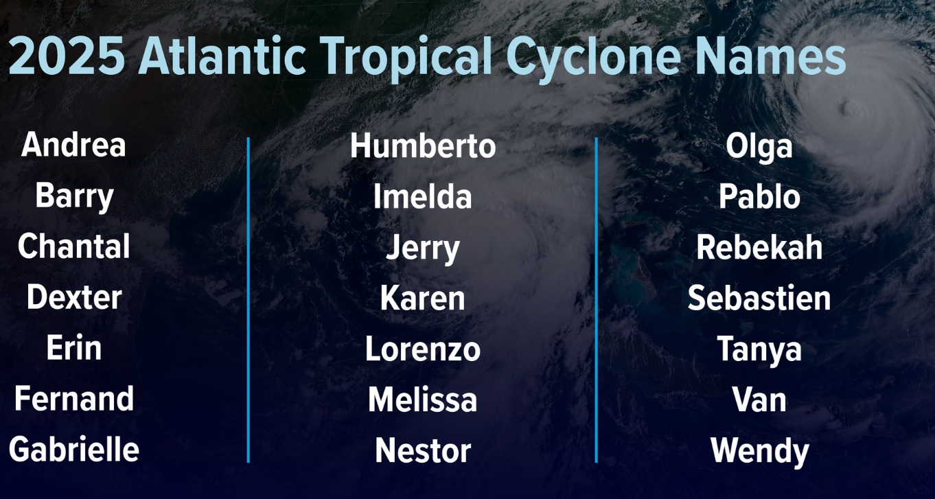
Since 1953, Atlantic tropical storms had been named from lists originated by the National Hurricane Center. They are now maintained and updated through a strict procedure by an international committee of the World Meteorological Organization.
If a storm forms in the off-season, it will take the next name in the list based on the current calendar date. For example, if a tropical cyclone formed on December 28th, it would take the name from the previous season's list of names. If a storm formed in February, it would be named from the subsequent season's list of names.
In the event that more than twenty-one named tropical cyclones occur in the Atlantic basin in a season, additional storms will take names from the Greek alphabet.
For more information please visit the Canadian Hurricane Centre:
https://www.ec.gc.ca/ouragans-hurricanes/?wbdisable=true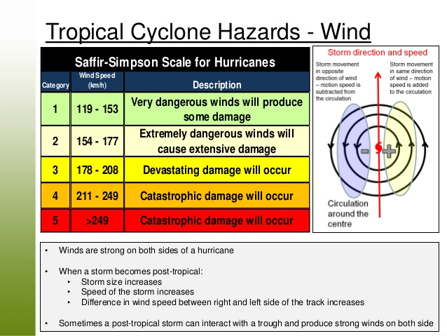
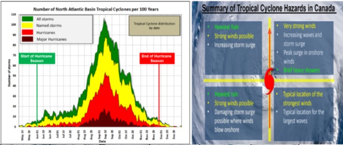


Learn about Hurricanes: hazards and impacts
When most tropical cyclones arrive in Canada or in Canadian waters they are in some stage of extratropical transition (ET). Even Hurricane Juan (2003), which stayed more tropical than most tropical cyclones when it reached Canada, was still undergoing ET. This is important because the weather and impacts from a transitioning tropical cyclone are different than those from the purely tropical cyclone. The weather is also different from a purely extratropical storm systems that are common in Canada.
Here is what you might expect with “post-tropical” cyclones.
- Wind
- Rain
- Storm surge
- Ocean waves
- Coastal waves
- Five common myths about hurricane waves
- Rip currents
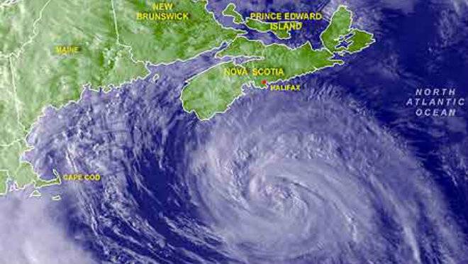
Hurricane Preparedness Tips
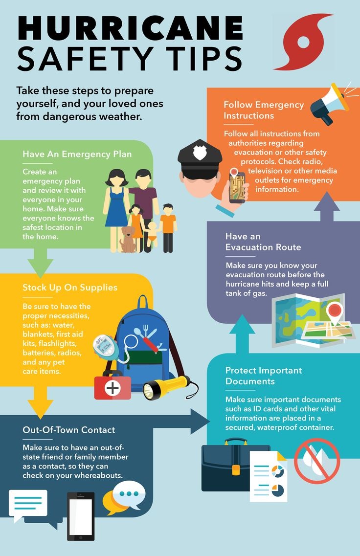
• Know the risks – Although the consequences of disasters can be similar, knowing the risks specific to our community and our region can help you better prepare.
• Make a plan – It will help you and your family know what to do
• Get an emergency kit – During an emergency, we will all need some basic supplies. We may need to get by without power or tap water. Be prepared to be self-sufficient for at least 72 hours in an emergency
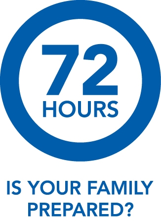

You should be prepared to take care of yourself and your family for a minimum of 72 hours. For more information on 72 Hour preparednessclick here

To get weather information when a storm is approaching Canada you can download the Environment Canada’s “WeatherCAN” App.
For more information on preparing a Home Emergency Plan, and to learn how to prepare for all types of emergencies, visit www.getprepared.ca
Click to Subscribe to these Annapolis REMO Options


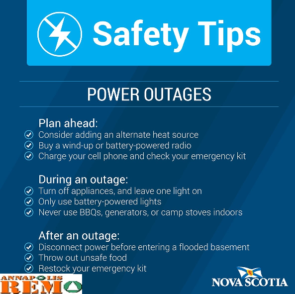
🚫🔌⚡Power Outages
Most power outages will be over almost as soon as they begin, but some can last much longer - up to days or even weeks.
During a power outage, you may be left without heating/air conditioning, lighting, hot water, or even running water. If you only have a cordless phone, you will also be left without phone service. If you do not have a battery-powered or crank radio, you may have no way of monitoring news broadcasts. In other words, you could be facing major challenges.
You can greatly lessen the impact of a power outage by taking the time to prepare in advance. You and your family should be prepared to cope on your own during a power outage for at least 72 hours.
 HIGH WIND SAFETY TIPS
Remember to prioritize your safety during periods of high winds. Taking proactive measures and staying informed can help minimize risks and ensure a safe experience during winter storms.
Stay Informed:
Monitor weather forecasts for wind advisories or warnings.
Stay updated on changing weather conditions, especially during winter storms.
Secure Outdoor Items:
Secure or bring inside any outdoor furniture, decorations, or objects that could become projectiles in high winds.
Check and secure items such as trash cans, garden tools, and lightweight structures.
Park Away from Trees and Power Lines:
If possible, park your vehicle away from trees and power lines to reduce the risk of falling branches or lines.
Be Cautious on the Roads:
Maintain a firm grip on the steering wheel, especially if driving in open areas where wind gusts can be strong.
Be alert for debris on the road, and avoid driving under overpasses or bridges during high winds.
Avoid High-Profile Vehicles:
If you're driving a high-profile vehicle like a truck or RV, be extra cautious. These vehicles are more susceptible to strong wind gusts.
Stay Indoors:
If possible, stay indoors during periods of high winds, especially during severe winter storms.
Avoid going outside unless absolutely necessary, as flying debris can pose a risk.
Prepare for Power Outages:
Charge electronic devices in advance.
Have flashlights, batteries, and other emergency supplies on hand in case of power outages.
Secure Windows and Doors:
Close and latch windows and doors securely to prevent damage from strong gusts.
If there's a risk of debris, consider putting up storm shutters.
Trim Trees and Branches:
Regularly trim tree branches that could potentially break and cause damage during high winds.
Remove dead or weakened trees to minimize the risk of falling.
Stay Away from Windows:
If high winds are accompanied by snow or ice, stay away from windows to avoid injury in case of shattered glass.
Have an Emergency Kit:
Ensure you have an emergency kit that includes essentials like water, non-perishable food, blankets, and a first aid kit.
Stay Updated on Alerts:
Sign up for local weather alerts and emergency notifications to stay informed about changing conditions

 Driving in strong winds can be challenging and potentially dangerous.
Here are some tips to help you stay safe:
Keep a Firm Grip: Hold the steering wheel firmly with both hands, especially if you feel gusts of wind. This allows you to maintain control of your vehicle.
Reduce Speed: Slow down to reduce the impact of strong winds on your vehicle. This gives you more time to react if the wind affects your control.
Stay Centered in Your Lane: Try to stay in the middle of your lane to allow for some leeway in case of sudden gusts. Avoid driving near large vehicles that might sway or lose control in strong winds.
Be Cautious Around Objects: Be extra cautious when driving near large objects like trucks, buses, or buildings. These can create wind tunnels that may affect your vehicle’s stability.
Pay Attention to Weather Reports: Check weather forecasts before traveling. If strong winds are predicted, consider postponing your trip if possible.
Watch for Debris: Strong winds can blow debris onto the road. Be vigilant and ready to react if something unexpected appears in your path.
Use Hazard Lights When Necessary: If the wind is severe and impairs your visibility or if you need to drive significantly slower than other vehicles, it might be helpful to use your hazard lights to alert others.
Keep a Safe Distance: Maintain a safe distance from other vehicles. This gives you more space to react if a sudden gust affects your or their control.
Be Prepared for Sudden Changes: Wind strength can vary in different areas or even suddenly change. Be ready for these variations and adjust your driving accordingly.
Stay Focused: Be attentive and avoid distractions. Strong winds require your full concentration.
If the winds become too severe, it might be best to find a safe place to pull over until the conditions improve. Your safety should always come first when dealing with extreme weather conditions.
If a Tropical Storm/Hurricane WATCH or Tropical Storm/Hurricane WARNING is Issued:
- Fill your bathtub(s) with water for flushing, washing and cleaning
- Be sure to tune in to local broadcast networks for updates from authorities
- Secure all gates, doors and windows
- Move lawn furniture, trash cans, hanging plants or anything that can be picked up by wind
- Trim dead or diseased branches from trees to help make them more wind resistant, or remove dead trees entirely. Safety should always be your first priority when trimming trees. Ensure that you are not working near a power line.
- Park your vehicles in a garage or away from trees
- Fill your car’s gas tank
- Keep pets indoors
- If you own a watercraft be sure it is out of water and up to high ground
FOR THE HOME
- Install storm shutters to all exposed windows and glass surfaces. This is the easiest and most cost-effective way to protect your home from this hazard.
- Garage doors: All garage doors can pose a hazard during a violent wind storm with doors more than eight feet wide being the most vulnerable. Many garage doors can be reinforced at their weakest points by installing wood or metal stiffeners. Some garage doors can be strengthened with retrofit kits.
- Roof: Homes with gable roofs are more likely to suffer damage during a hurricane. A gable roof looks like an "A" on the ends, with the outside wall going to the top of the roof. Check to see if your home has truss roof bracing; if not, be sure to have it installed. If you are replacing your roof, take steps to ensure that both the new roof covering and the sheathing to which it is attached will resist high winds.
- Connections: The points where the roof and the foundation meet the walls of your home are extremely important if your house is to resist high-winds and the pressure they place on the structure.
- Have a professional install hurricane straps – these are designed to help hold your roof to the walls.
- If your home has more than one storey, make certain that the upper storey wall framing is firmly connected to the lower framing.
PERSONAL SAFETY
If you are indoors
- Stay indoors, away from glassed areas.
- Turn on a battery-operated radio and listen for the latest emergency information.
- If told to leave, take your disaster safety kit and go immediately to the designated shelter. Be sure to follow the recommended evacuation routes - never take shortcuts.
- If in a mobile home, get out and seek shelter elsewhere.
- If power is lost, turn down major appliances to reduce power "surge" when electricity is restored.
If you are outdoors
- If possible, get inside a building.
- If there is no shelter, lie down in a ditch or ravine.
- Use your arms to protect your head and neck.
- Stay away from bridges and overpasses.
If you are in a vehicle
- Immediately stop the car and turn off the engine.
- Get out of the vehicle and seek shelter in a building, ditch or ravine. Become familiar with your community's hurricane warning system. Every member of your family should know what to do when a hurricane warning or watch is released. Learn about the disaster safety plans in the workplace and at your home.
Hurricane disaster supply kit
- Canned goods and nonperishable foods that do not need cooking:
- Canned meats and fish
- Canned fruits and vegetables
- Canned soups and puddings
- Canned fruit juices
- Dried fruit and nuts Bread, cookies and crackers
- Peanut butter and jelly
- Coffee and tea
- Manual can opener
- Bottled water (one gallon per person/per day)
- Prescription medication (two-week supply)
- Pet food/supplies
- Water purification tablets
- Disposable plates, cups, and utensils
Infant care items
- Disposable diapers
- Baby wipes
- Baby food /Formula
Other useful items
- First Aid Supplies
- Masking and duct tape
- Flashlight or lantern, with extra batteries
- Battery operated radio, with extra batteries
- Watch or battery operated clock
- Ice chest
- Matches
- Canned heat (sterno)
- Portable outdoor camping stove or grill with fuel supply
- A certain amount of cash
- Plastic trash bags
- Plastic sheeting or tarp
- Personal hygiene items
- Work gloves
- Sun lotion
- Insect repellent
- Hammer
- Screwdriver
- Pliers
- Wrenches
- Handsaw
- Razor knife Ax or chainsaw
- Rope caulking
- Nails and screws
- Rope and wire
- Broom, mop and bucket
- All-purpose cleaner
- Ladder
- Sandbags
- Portable generator
- Shovel, rake and wheelbarrow
- Sheets of plywood
